
-
- About
- Administration
-
Govt. Office
Human Resource Development
-
Office of Women Affairs Officer
-
Employment and Manpower Office
-
BRDB
-
Islamic Foundation
-
Cooperative
-
District Savings Office, Gaibandha.
-
Labor Welfare Centre, Gaibandha
-
Social service
-
UCD, Gaibandha
-
Government Child Family (Girls), Gaibandha
-
Government Child Family (Boy), Gaibandha
-
BCIC
-
Sports
-
Tax
-
JMS
-
■ Hospital social services office, gaibandha
-
logo Office of the probation officers, Gaibandha
-
youth development
Education and Cultural Affairs
-
District Primary Education Office
-
District Education Office
-
Children\'s Academy
-
District Bureau of Non-formal Education
-
Gaibandha Shilpakala Academy
-
Public Libary
-
logo Temple Based Education, Gaibandha
-
Primary Teachers Training Institute (PTI)
-
Textile Vocational Institute, Gaibandha.
-
Gaibandha Government Technical School and College
-
Gaibandha Govt College
-
Gaibandha Government Girls High School
Agriculture and food
-
Department of Agricultural Extension
-
Food Controller\'s Office
-
District Fisheries Office
-
District Livestock Office
-
Livestock training institute
-
Department of Jute
-
Barind Multipurpose Development Authority
-
ILST
-
District Seed Certification Office
-
■ District Artificial Insemination Center, Gaibandha
-
BADC (sm)
-
District markrting ofice
-
District Forest Office, Gaibandha
-
Bangladesh Food Safety Authority, Gaibandha
-
Soil Resources Development Institute (SRDI)
-
Office of Women Affairs Officer
- Other Institute
- Laws
- E-Service Center
- Gallery
- ছাত্র-জনতার গণঅভ্যুত্থানে শহিদদের তালিকা
- স্মার্ট ভূমিসেবা
-
-
About
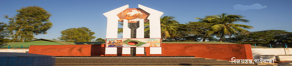
About
History and tradition
Geographical and economical
-
Administration
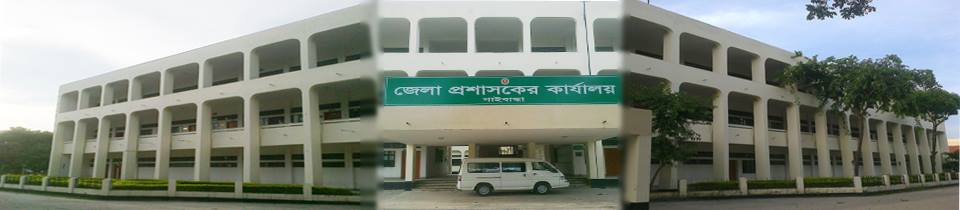
Deputy Commissioner
Deputy Commissioner\'s Office
Additional Deputy Commissioners
Officers and Employees
Important information
Branch related
Innovation activities
-
Govt. Office
Human Resource Development
- Office of Women Affairs Officer
- Employment and Manpower Office
- BRDB
- Islamic Foundation
- Cooperative
- District Savings Office, Gaibandha.
- Labor Welfare Centre, Gaibandha
- Social service
- UCD, Gaibandha
- Government Child Family (Girls), Gaibandha
- Government Child Family (Boy), Gaibandha
- BCIC
- Sports
- Tax
- JMS
- ■ Hospital social services office, gaibandha
- logo Office of the probation officers, Gaibandha
- youth development
Education and Cultural Affairs
- District Primary Education Office
- District Education Office
- Children\'s Academy
- District Bureau of Non-formal Education
- Gaibandha Shilpakala Academy
- Public Libary
- logo Temple Based Education, Gaibandha
- Primary Teachers Training Institute (PTI)
- Textile Vocational Institute, Gaibandha.
- Gaibandha Government Technical School and College
- Gaibandha Govt College
- Gaibandha Government Girls High School
Agriculture and food
- Department of Agricultural Extension
- Food Controller\'s Office
- District Fisheries Office
- District Livestock Office
- Livestock training institute
- Department of Jute
- Barind Multipurpose Development Authority
- ILST
- District Seed Certification Office
- ■ District Artificial Insemination Center, Gaibandha
- BADC (sm)
- District markrting ofice
- District Forest Office, Gaibandha
- Bangladesh Food Safety Authority, Gaibandha
- Soil Resources Development Institute (SRDI)
Health
Engineering
Law, order and safety
Communication and Information Technology
-
Other Institute
educational institutions
Religious institutions
organization
Private organization
বিনিয়োগ প্রতিষ্ঠান
- Laws
-
E-Service Center
District E-Service Center
National E-Service Center
-
Gallery
Videos Gallery
Photo Galarry
-
ছাত্র-জনতার গণঅভ্যুত্থানে শহিদদের তালিকা
শহিদদের তালিকা
-
স্মার্ট ভূমিসেবা
■ সকল স্মাট ভুমিসেবা
Deputy Commissioner's Office, Gaibandha
Phone number 0541-51226
Fax number - 0541-51483
E-mail: dcgaibandha@mopa.gov.bd
Web Portal: www.gaibandha.gov.bd
Gaibandha district has water and land communication. The details are discussed below-
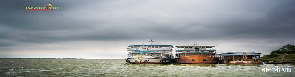
Ancient settlements, business centers, administrative centers, Bhabaniganj, Kalganj, Sundarganj, Gobindganj, Ghoraghat, Tulshasighat, Gaibandha, Badiakhali, Mahimaganj, Sahebganj etc. were formed on the banks of the rivers of Gaibandha district. The medium of communication was small and big boats, barges.
Both Rangpur and Gaibandha are situated on the banks of the river Ghaghat. The boat was the means of communication. When the Ghaghat was connected to the Brahmaputra river in 1907-08 with the connection of the Baguria canal, the opportunities for trade and commerce increased. Gaibandha jute is exported to Narayanganj-Dhaka by river. Mahajani goods come to Gaibandha from Dhaka and big boats with coconuts come from Khulna-Barisal. The river Teesta used to connect Dhaka and Khulna through Rangpur-Haragach Sundarganj. The Karatoya river used to be connected to Ghoraghat from Pundravardhana (Mahasthan) via Gobindaganj in ancient times. The Pathan rulers from Ghoraghat also maintained contact with Dhaka via Mymensingh through Karatoya. Within the district, small port canals were used to travel to various port huts and localities. The railway connected Calcutta and Assam before it was introduced. The ships of "River Scheme Navigation Company and India General Scheme Navigation Company" used to sail from Calcutta to Assam. There was a steamer station at Kaliganj (Bhabaniganj thana, Rangpur district) on the banks of the Brahmaputra river. At that time the communication system of the district was based on this ghat.
Road is the means of communication by land. The roads around the district are spread like a net. In the past there were means of transportation on foot, bullock carts and horse or horse-drawn carriages. At present the roads have been substantially improved and modern bus services are being used as trucks. Business centers and urban civilization have developed along these roads.
The former roads of Gaibandha district were (1) Ghoraghat to Gobindaganj via Mymensingh to Dhaka (2) Ghoraghat to Kamdia, Raja Virat Panitla Hat to Kichak to Mahasthan (3) Ghoraghat to Karatoya to Brahmaputra. Still seen in the south (long west-east). There was a road from Ghoraghat to Rampur east of Komarpur Hat. Rampur was the former home and kachari of the kings of Vardhanakuthi which belonged to Barisal mouza. A highway through Sariakandi, Sonatala, Jumarbari touched Badiakhali, Thansinghpur in Gaibandha district and reached Bhabaniganj. They no longer exist completely. There is little mention of this in various reports and regional history texts.
Surveyor General James Rennell surveyed the area from 1764-72 to see the road connections with many famous places. Ghoraghat Cooch Behar Road, known as Raja Nilambar Road, Ghoraghat Gobindganj Mymensingh Dhaka Highway is one of them which passes over the present Gaibandha district. He also mentioned Rangpur Shibganj (Bogra) road and Rangpur Kamdia road.
One hundred years after that survey, in 1871-72, W. Hunter's account shows that the two main roads of the former Rangpur district passed over Gaibandha district. One of these Rangpur Padhara (Bogra) road is 30 miles long and Rangpur Bhabaniganj road is 45 miles long. The importance of this road was immense as there was a steamer station at Kaliganj adjacent to Bhabaniganj subdivision and there was an opportunity to transport goods from here to Assam-Calcutta. Wooden bridges were used on the roads. A. C. Hartley's (1931-38) 6-year report found that traces of old roads had largely disappeared. Yet the roads of the former Rangpur district, which have touched Gaibandha. They are:
1. Rangpur Pirgacha, Bamandanga, Naldanga, Kamarpara, Gaibandha roads. 2. Rangpur, Mithapukur, Pirganj, Palashbari, Gobindganj, Bogra roads. 3. Gaibandha, Sadullapur, Baradarga, Badarganj roads. 4. Gaibandha, Palashbari Road. 5. Gobindaganj-Mahimaganj road.
Thirty-five miles of the National Highway, now known as Bishwaroad, passes from Dhaperhat of Sadullapur Police Station to Palashbari Police Station and ends at Gobindganj Police Station after Chapariganj Madrasa. The entire Gaibandha district has 193 km of paved roads, 130 km of semi-paved roads and 2304 km of unpaved roads. There are 365 bridges and 1281 culverts.
In 1875 a company called Northern Bengal State Railway launched the first railway in North Bengal. Before 1900, a meter gauge railway was extended from Parbatipur to Rangpur Kaunia Dhubri and from Santahar to Bogra Bonarpara to Fulchhari Ghat. The railway from Bonarpara to Kauniya was added in 1907-09. The railway stations of Gaibandha district are: Bamandanga, Naldanga, Kamarpara, Kuptala, Gaibandha, Trimohini, Balasighat Railway Ferry Station, Badiakhali, Bonarpara Junction, Mahimaganj, Bharatkhali, Fulchhari, Tistamukh Ghat Railway Station. The total distance of railways in this district is about 52 miles. The former Dinajpur Rangpur district has a good railway system with Dhaka.


Planning and Implementation: Cabinet Division, A2I, BCC, DoICT and BASIS
Technical Assistance:
![]()
Developed By:
